
BADAS 2.0
The world's best incident prediction model, period.
BADAS 2.0 is a world model that has internalized physics and causality. Wetrained it on 2M real-world driving clips. We fine-tuned NVIDIA's Cosmos on thesame data. BADAS wins – at 91x fewer parameters. We publish everything. Try ityourself.
%20(1).avif)
Run BADAS 2.0 on Your Own Video
Watch the world's best incident prediction and understanding model in action.
.svg)
Upload Your Own Video. See What BADAS 2.0 Sees.
Drag an EGO POV video. Get predictions, attention heatmaps, and natural language reasoning – in seconds.


%20(1).avif)
0.994 AP vs 0.940. Same Data. Different Architecture.
We fine-tuned NVIDIA's Cosmos-Reason2-2B on the exact same 2M training clips. BADAS 2.0 achieves 99.4% AP. Cosmos achieves 94.0%. At 91x fewer parameters, our smallest model still beats their largest. We publish our benchmarks and invite direct comparison.

.avif)
.svg)
The Work Zone Crisis
Every year, U.S. work zones claim nearly 900 lives, strip cities of over a billion dollars in unpaid fines, and add half a billion hours of congestion to American roads. The root cause is always the same: no one knows what’s actually happening out there.

NYC DOT processes 700,000 street construction permits a year, but a State Comptroller audit found nearly 300,000 received no inspection at all. 150 field inspectors. 6,000+ miles of streets. Every un-inspected permit is a compliance gap, a safety risk, and an uncollected fee hiding in plain sight
.svg)
Real-time road intelligence. Updated daily by the vehicles already driving your streets.
CityStream Work Zones uses Nexar’s nationwide fleet of 350,000+ AI-powered dashcams to continuously detect, classify, and monitor road work zones — at city scale, at state scale, across the entire U.S. main road network.
.avif)
No survey trucks. No drones. No field visits required. Ground-truth intelligence, delivered continuously.
.svg)
How It Works

Dashcams Collect
350,000+ AI-powered dashcams already on U.S. roads passively capture ground-level imagery as they drive through work zones. No special hardware deployment needed.
.avif)

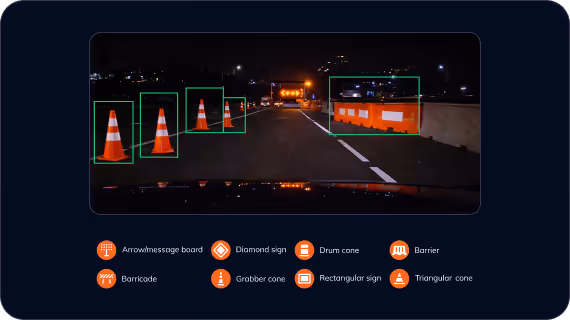
AI Detects
Nexar’s AI analyzes imagery to identify and classify 8 types of work zone elements — from grabber cones to arrow boards to barriers. Each detection is GPS-tagged, time-stamped, and accompanied by photographic evidence.

Permit Cross-Reference
Detected work zones are cross-referenced against permit databases in real time. Overstays, early starts, and unpermitted activity are flagged automatically — with photo evidence attached.
.avif)

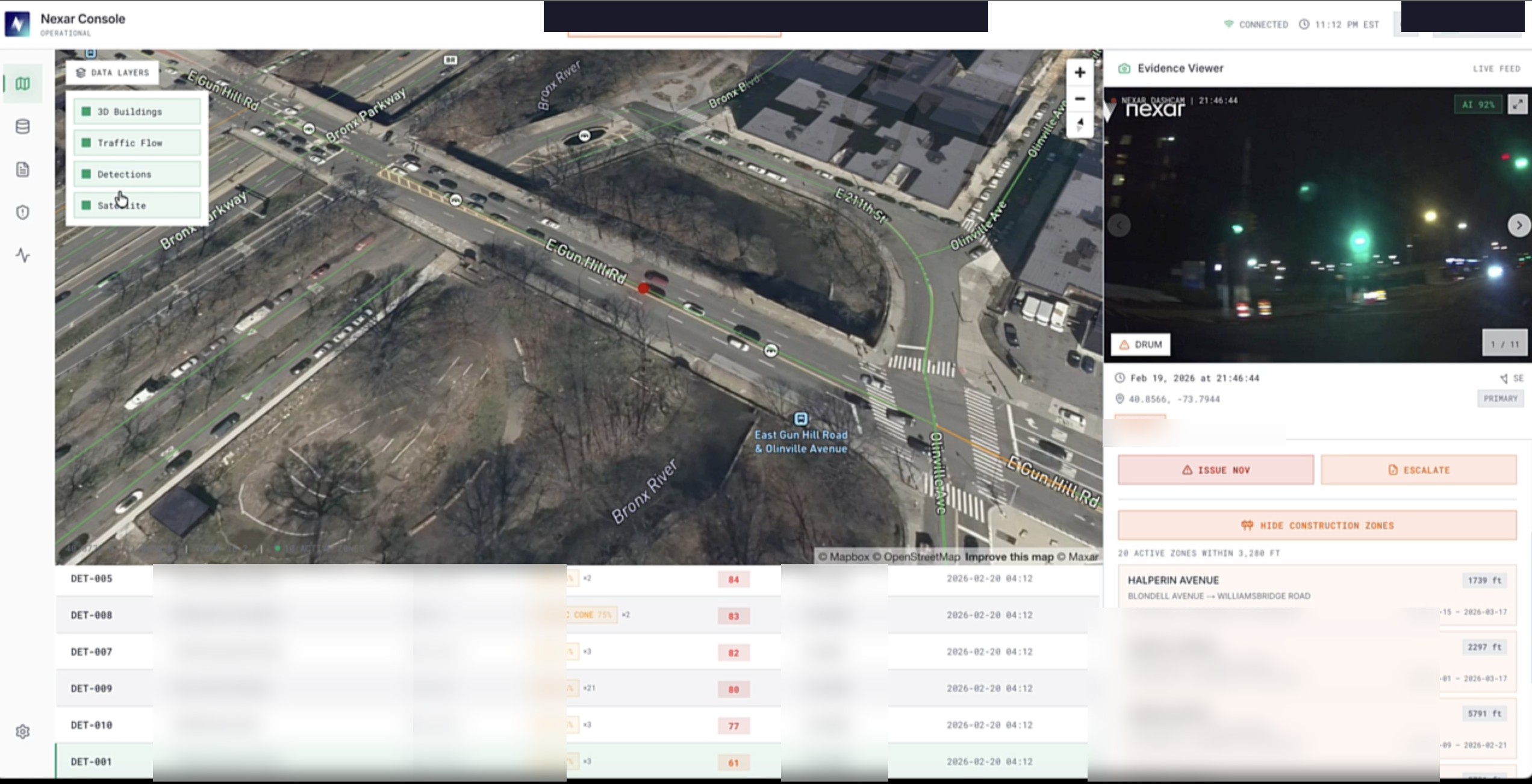
Map & Monitor
Detections are aggregated, geolocated, and displayed on an interactive map. DOTs can monitor all work zones across their jurisdiction, track changes over time, and export via API or WZDx-compliant feed.
.avif)
.avif)

Why CityStream

See Every Work Zone Without Leaving Your Desk
DOT staff currently send crews to physically drive through work zones to verify conditions. CityStream replaces manual compliance checks with continuous remote monitoring — dramatically reducing officer time on site visits and enabling proactive enforcement without adding inspection burden.

Know What’s Really Happening,Not What’s on the Permit
Detected work zones are automatically cross-referenced against permit data. The system flags overstays, early starts, and unpermitted activity — with photographic evidence. Ground truth, not paperwork.

The Freshest Road Datain the Industry
Highways refreshed in days. Arterials in about a month — roughly 50x faster than traditional survey cycles. 98% of U.S. main roads visited monthly. This isn’t once-a-year survey data. It’s continuous monitoringat scale.

WZDx Compliance, Out of the Box
CityStream outputs WZDx-compliant data natively — feeding accurate work zone data to mapping services, connected vehicles, 511 systems, and other agencies. 23+ state agencies already participate. Stay ahead of the federal standard with zero extra lift.

Revenue Recovery at Scale
Revenue Recovery at ScaleWork zone permit violations are a massive, largely untapped revenue source. NYC alone has $1.4B in uncollected enforcement fines. CityStream’s compliance layer identifies non-compliant and unpermitted work zones — opening a path to recover fees that currently go undetected. In the City of LA, the platform is funded through recovered compliance and violation fees. It pays for itself.

Reduce Congestion. Improve Traveler Information
Work zones cause 24% of all non-recurring U.S. traffic congestion. Greater permit compliance accountability reduces unnecessary lane closures. Real-time work zone updates feed directly into 511 systems and WZDx feeds — improving traveler information accuracy across the board.

No survey vehicles. No new infrastructure. Immediate insights.
Everything in CityStream is powered by the Nexar dashcam network — 350,000+ AI-powered cameras already on U.S. roads, capturing the world as it actually is
.svg)
350,000+
AI dashcams deployed nationwide across consumer and fleet customers.

98%
of U.S. main roads visited every month.

80+ million
detections per day.
.svg)
Privacy-first by design:
on-device anonymization, no route sharing, GDPR and CCPA compliant.

Nexar owns the hardware
end-to-end control over quality, AI processing, and privacy
Mean Time Between Visits - All Road Types

Deployed across cities and states that can’t afford to guess
City of Los Angeles
A trusted partner for work zone compliance - LA has relied on CityStream for 3+ years to monitor thousands of active work zones across 23,000 lane-miles."
Partner DOT
Statewide DOT deployment demonstrating Nexar’s ability to operate at scale across an entire state’s road network.

.svg)
.svg)


WZDx-compliant. Out of the box.
The Work Zone Data Exchange (WZDx) is the federal standard for sharing work zone information with vehicles, navigation systems, and other agencies. 23+ states already participate. CityStream Work Zones outputs WZDx-compliant feeds natively — no integration work, no custom build. As connected and autonomous vehicles become the norm, WZDx compliance will be critical infrastructure. You’re already ready.
.png)
No driver data. No vehicle tracking. No exceptions.
Nexar’s on-device AI automatically blurs faces and license plates before any image ever leaves the dashcam. Driver routes are never shared. Start and end points are stripped. All tracking IDs are ephemeral — no individual driver can be identified or traced. Zero personally identifiable information is present in any work zone data delivered to customers.
.png)
See your roads clearly
Schedule a live demo and see CityStream Work Zones monitoring your jurisdiction in real time.
.png)

Your Teams Can't Be Everywhere. Now They Don't Have To Be.
Work zones are dynamic. Traditional oversight models are not.
By the time an issue is identified through an inspection, report, or complaint, theoperational moment may already be gone.
.svg)
Field Inspections
Self-Reporting
.svg)
Complaints & Incident Reports
after the fact.

Know Your Roads as They Are, Not as They Were.
Nexar provides AI-powered road intelligence that detects work zone activity from alarge, continuously refreshed connected camera network covering the majority of U.S.roads.
Using machine learning models, Nexar identifies work zone elements such as cones,barriers, barricades, and signage, then maps them into structured, geolocated workzone records.
This is not just what was planned. It is visibility into what appears to be happening onthe road.
How It Works

Observe

Detect
Map
Bring into Workflow
.avif)
See Every Work Zone. Act on What Matters.
.svg)
Improve Visibility into Active Work Zones
.svg)
Surface Potential Permit Compliance Issues
.svg)
Reduce Blind Spots in Oversight
.svg)
Focus Manual Effort Where It Matters Most
.svg)
Support Operational Workflows
.avif)
Intelligence That Shows Up Where Your Team Already Works.
Detection alone is not enough. Operational teams need a way to review, route, and acton roadway intelligence efficiently.
Available through IBM watsonx Orchestrate, Nexar’s work zone intelligence can bebrought into agency workflows to support faster, better-informed decisions.
Access road intelligence in a workflow environment
Reduce reliance on disconnected monitoring tools
Support more efficient review and response processes
Bring observed roadway signals closer to operational action
.avif)
Backed by the Largest Road Observation Network in the U.S.
Cameras
Coverage
Detected Daily
Refreshed
Weekly
Detected

Frequently Asked Questions
.avif)
Take Control of Every Mile You Manage.
Talk with Nexar about work zone intelligence for transportation agencies and how it can be brought into workflow through IBM watsonx Orchestrate.
.avif)