Executive Summary
Snow-covered roads significantly increase the risk of accidents and disrupt essential mobility. According to the Federal Highway Administration (FHWA), more than 1,300 people are killed and over 116,800 are injured each year in crashes on snowy, slushy, or icy pavement. Despite this risk, most transportation agencies still rely on manual driver reports and limited sensors to assess road conditions, leaving critical gaps during fast-changing weather events.
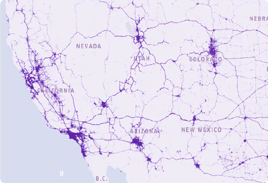
To improve safety and situational awareness, one of the nation’s largest Departments of Transportation (DOT) partnered with Nexar and CompassCom to automate snow condition detection using AI-powered dash cams. Nexar’s Vision AI runs directly on the camera, detecting snow coverage in real time. This capability is deployed on state-owned snowplows equipped with Nexar dash cams and across Nexar’s broader crowdsourced network, with all detections aligned to the DOT’s operational categories.
The project began with a 20-vehicle Proof of Concept that captured road imagery under a wide range of snow conditions. Using this data, Nexar’s Vision AI demonstrated the ability to automatically assess snow levels on the road in line with the DOT’s operational standards. With these results validated, the DOT is now equipping its full fleet of 1,800 snowplows with Nexar dash cams, enabling automated snow condition detection at scale for faster response and safer winter roads ahead of the 2025–26 snow season.
Challenge
A DOT responsible for roadway maintenance and safety needed a more reliable and scalable approach to monitor snow coverage during winter operations. Accurate road condition assessment is critical to prioritizing response efforts, allocating resources efficiently and ensuring public safety. However, the agency’s traditional methods relied on periodic driver reports and scattered fixed sensors, which provided limited coverage, inconsistent reporting, and lacked the real-time visibility necessary for data-driven decision-making.
To overcome these limitations, the DOT sought a solution that could deliver automated, consistent, and visual assessment of road conditions directly from the field. The objective was to enable real-time monitoring, historical documentation, and standardized classification of snow coverage across the network.

Solution Overview
To address this challenge, Nexar partnered with CompassCom, a leader in geospatial fleet management, on a Proof of Concept integrating AI-powered dashcams with live fleet data in CompassCom’s Esri-based AVL platform. To ensure operational relevance, Nexar’s Vision AI was trained to align with the DOT’s classification framework.
The initial deployment involved installing 20 Nexar Beam2 dash cams on snowplows operated by the agency. This setup enabled the collection of thousands of roadway images under varying snow conditions, providing a diverse and representative dataset. Subject-matter experts then annotated these images to create high-quality training data, which served as the foundation for training Nexar’s Vision AI system to classify road surface conditions according to the DOT’s grading standards.
To ensure alignment with operational needs, Nexar tailored its AI model to detect a custom range of snow condition categories based on the DOT’s specific classification scheme. Following training, the model was deployed over the air to the dashcams to validate system performance during the most recent snowfall events, allowing the agency to assess detection accuracy in real-world conditions.
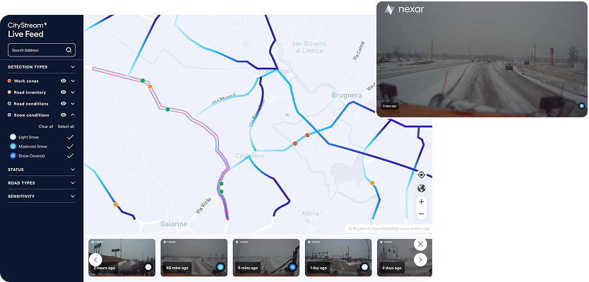
Finally, the system was seamlessly integrated into CompassCom’s operational platform via Nexar’s APIs. This integration provided real-time visibility into roadway conditions and supported automated workflows without requiring additional infrastructure, ensuring that the solution could scale efficiently within the DOT’s existing fleet management environment.
While this PoC focused specifically on snow condition detection, Nexar’s broader CityStream platform enables additional road intelligence capabilities for future integration.
Outcomes & Impact
The Proof of Concept demonstrated that Nexar’s AI-powered dash cams can accurately detect and classify road snow conditions in real time, delivering consistent and actionable insights across the fleet.
Trained on real-world imagery captured during snowplow operations, the model provided visual data aligned with operational needs. Detection results, including condition, timestamp, location, confidence, and supporting imagery, were integrated into CompassCom’s platform to enhance situational awareness and support automated workflows.
“The process using AI at the edge with Nexar technology has automated the determination of current road conditions for snowfighting activities,” said Brant Howard, Founder and CEO of CompassCom Software. “The Nexar AI integrated into our CompassVision real-time platform replaces the unsafe and inconsistent manual process of pushing a button on a tablet to map conditions. From the machine learning process applied to the cameras through deployment of the AI, DOTs are now receiving more accurate and consistent data while improving driver safety.”
By moving from manual, self-reported updates to automated, AI-driven perception at the edge, the DOT gains:
- More consistent condition reporting across the fleet
- Improved driver safety by eliminating the need for manual in-cab inputs
- Faster identification of priority corridors for plowing and treatment
- A visual audit trail that supports performance measurement and after-action review
Architecture Overview
Nexar dash cam → Edge AI → CityStream API → CompassCom dashboard (Esri-based)
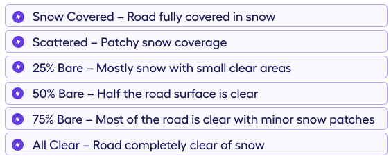
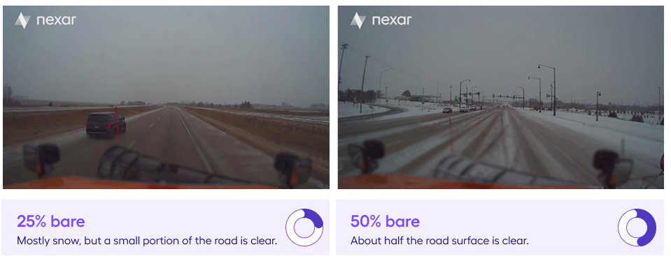
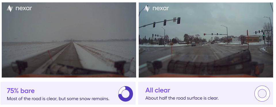
Snow Condition Categories (customized for the DOT)
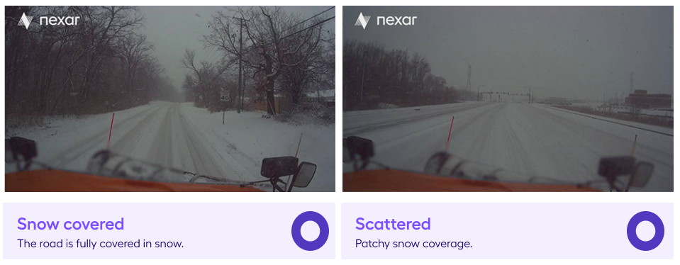
Visual Evidence
Conclusion
This Proof of Concept highlights the transformative potential of integrating vision-based AI into fleet operations. By automating the detection of road snow conditions, which were previously reliant on manual reports, the DOT gained access to consistent, scalable, and verifiable insights that supported faster, safer, and more informed decision-making.
The success of this initiative demonstrates how real-time visual perception, delivered through connected dashcams and edge AI, can unlock new operational capabilities. These extend beyond winter response to include infrastructure monitoring, asset management, and roadway safety analysis.
By aligning with existing workflows and integrating seamlessly with CompassCom’s Esri-based AVL fleet platform, the solution proved both effective and immediately actionable. For the DOT, moving from a 20-vehicle pilot to a statewide deployment reflects the growing recognition of the value that visual intelligence brings to public operations.
As public agencies continue to modernize, the ability to capture and act on road-level insights in real time will become essential. This capability will support not only snow operations but the development of smarter, safer, and more resilient road networks.
Want to dive deeper?
Nexar helps industry leaders turn vision into value. Dive into real-world success stories where our data redefined the road ahead - and see what it can do for you.